Preservation Project
Background
The furnace site was first recorded and excavated by Chichester District Archaeological Unit in 1989. It became apparent that there was a long standing threat to the lower parts of the site from erosion as excessive volumes of water from the furnace pond poured through a 1940s sluice in winter, washing away parts of the wheel-pits and tail race. An assessment of the scale and rate of destruction was possible in 1989 thanks to an earlier (1976) survey drawing of the area by Haslemere Archaeological Society, but there has been further dramatic erosion since during the 1990s. Attempts have been made to minimise further damage, but the long-term solution will incur considerable costs.
The furnace site is currently under dual ownership of Robin and Carla Barnes who own the east side of the structure, and the Cowdray Estate who own the other half. West Sussex County Council has an interest in that the site is crossed by a public bridle path therefore it has a duty of maintenance.
Independent experts from the Wealden Iron Research Group have confirmed that the site is as well preserved as any in the south of England.
The site has been scheduled by English Heritage under the Ancient Monuments and Archaeological Areas Act 1979 as amended as it appears to the Secretary of State to be of national importance. English Heritage List entry number 1021403 refers.
Linchmere: North Park Furnace (SU 283 877)
Excavation and recording 1989
The site lies in mature woodland on a small stream forming the boundary of Fernhurst and Linchmere parishes, about 600m south of Lower Lodge Farm. In June a detailed survey and limited excavation was carried out because the wheel race complex was suffering erosion from floodwater and the roots of large trees were damaging the buried remains of the furnace and other features. It was also intended to assess the degree of preservation of the complex with a view to consolidating and displaying the remains as part of an educational trail.
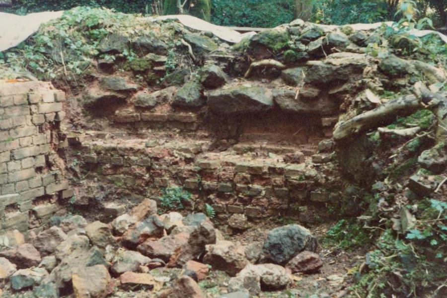
Before excavation, the visible remains consisted of a large pond retained by a dam or bay pierced by two sluices (Fig. 16). The southern sluice, of 18th century ashlar construction, is currently being repaired by the owner, Mr Robin Barnes. The northern sluice, replacing one washed away in 1928, carried water into the wheel race complex of the former ironworks. On the northern bank of the stream the masonry remains of the furnace were visible amongst the trees, and the recent erosion of the sides of the stream had revealed other features in section. To record features in the stream bed, debris was removed from the culvert and tail race, thereby lowering the water level by about 0.6m. This revealed large timbers on which the original bay had been built, and a circular brick-lined structure which partial excavation showed to be a gun-casting pit. A detailed 1:20 drawing of in situ stonework, brick-work and timbers was made.
North of the casting pit lay the furnace, which was about 5m square at the base. Excavation revealed the brick lining of the furnace in place against two of the walls, but nothing remained of the hearth. A small excavation to the west of the furnace, where the bellows would have been situated, revealed the face of a masonry revetting to the pond bay. Detailed analysis of the remains has yet to be completed, but at least three phases of construction could be seen in the wheel pit and tail race, and it may be possible to link constructional phases to the recorded history of the site.
Elements of the ironworks which have still to be located include the boring-place, where cannon were drilled out, which may lie on level ground due east of the furnace, and a possible forge on the south-west bank of the stream, since at one phase there seems to have been provision for two water wheels, one driving the bellows and the other presumably a large hammer.
The site of a shanty town occupied by 18th century ironworkers is known on the north side of the pond, and the nearby minor place-names Furnace Wood and Minepit Copse indicate the source of the charcoal and ore used.
North Park is the best surviving example of an ironworks in West Sussex, and no similar site in the Weald has been consolidated and displayed for the general public. Given the former importance of the industry in south-east England, this is regrettable. At North Park there is relatively easy access by footpaths and bridle paths, the remains are well preserved and the owners are eager to see the site consolidated and displayed. A strong case can be made out for further excavation in 1990 onwards with this as the objective if necessary funds can be obtained.
John Wildman
Chichester District Archaeological Unit
Excavation and recording 1992
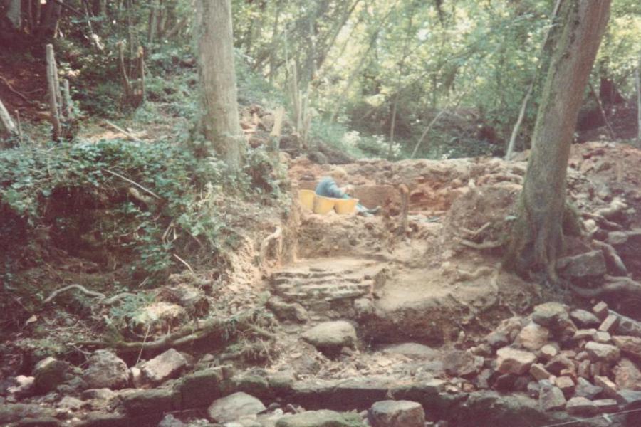
The limited excavations carried out in 1989 were to have been followed by a further investigation in 1990, but resources did not permit it. In order to protect the brickwork of the furnace base from frost damage and weathering, the remains had been covered with straw and tarpaulins but this was not adequate for long-term preservation. In the autumn of 1992 the area was covered by a permeable polythene membrane and backfilled with sand. The time allocated for this work proved to be over-generous, and the opportunity was taken to investigate a further area of the site where a scatter of roofing tiles indicated a building to the east of the furnace. This was similarly backfilled after recording.
The 1992 site was in an area of large trees, some of which were growing through the remains. The scatter of tiles sealed a very thin layer of soil above an extensive brick floor which was of several phases of construction, and which may represent two buildings and a yard. At the western end of the area was a sub-circular raised hearth (101) constructed of Greensand, its east side bonded into a north-south stone wall (102) faced with brick forming the east wall of a building, and its north side forming part of the north wall. Butted up to the hearth was a brick floor (105) bounded by a drainage gully (117) on the west. There was no certain trace of a wall footing here, so the building may have been open-sided. Its southern limit was not determined, but the room was at least 4m long. To the south of the raised hearth the brick floor originally incorporated a hearth at floor level made of bricks set on edge (106). This was replaced by a second raised hearth (104) similar to (101) but made of bricks. Outside the building, butted up to the wall (102), was a short brick wall (111) which, although a secondary feature, may be associated with the early hearth (101). Since the hearth was exposed but not excavated the function of the wall is unclear.
Adjoining the north-east corner of the first building was a well-laid brick floor (108) bounded on the north, west and south by a narrow stone wall foundation (107,110) and incorporating a gully (109) one brick wide at its western end, formed by sinking a row of bricks about 50mm below the general floor level. The structure measured roughly 2.1m by 7.5m internally, and had a drainage gully similar to 117 at its eastern end.
To the south of wall 107 was a further area of brick floors. Next to wall 102 was a small area of badly pitted bricks laid east-west (112) 0.8m wide and at least 1.2m long. Next to it was a larger brick-paved area (113) bounded on the east by a beam-slot (115). Beyond this was a small area of square tiles with a further beam-slot (116) marking its eastern edge, beyond which was a very small area of disturbed bricks perhaps representing further paving.
The area south of wall 107 and east of wall 102, characterised by irregularly laid brick and tile surfaces, may be interpreted as a paved yard. The badly disturbed area of 113 occurs in the middle of the building represented by floor 108 and could indicate the site of a doorway. The tiled floor 114 and beam slots (115, 116) may constitute a fuel bunker or something of that nature, as may the brick floor 112 to the west, which is of identical width. The date of the area’s use was indicated by a coin of George III (1733) found on top of the brick paving 113. Of the two buildings identified, the structure represented by floor 105 seems to be earlier both on stratigraphic grounds and because of the more extensive use of Greensand. It plainly had a specialised function but its precise nature is unclear. The hearths could perhaps suggest a smithy. The long, narrow building represented by floor 108 must also have had a distinctive function but its use is uncertain.
South of the tail-race a trench was dug on the line of a timber-lined drain (15) noted in 1989 protruding from the eroded bank of the stream. The trench, sited 4m south of the stream, was dug through layers of hard-packed redeposited clay and slag. In the base of the trench was found an iron grid set in a brick surround. Further erosion of the south bank of the stream since 1989 had revealed additional floors and walls which were added to the drawn section. These must represent buildings which had gone out of use before the final phase of the furnace’s operation.
John Magilton John Wildman
Chichester District Archaeological Unit
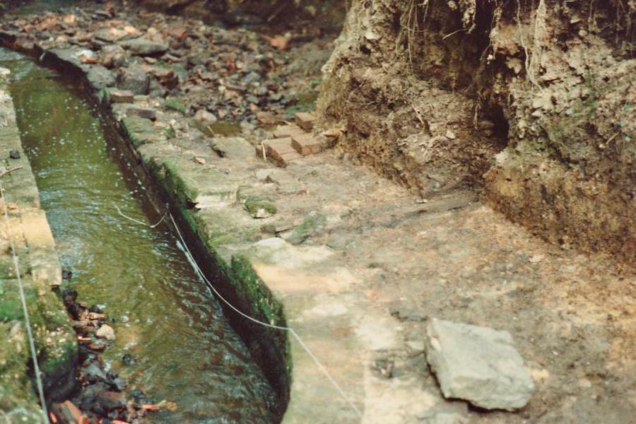
In the Annual Report for 1989 it was stated that a long-term aim of the project was to consolidate and display the remains of the furnace. In the then financial climate, this ambition seemed as far away as could be. However, the problem of site erosion (which inspired our initial recording of the furnace) persisted, and the only medium-term solution was to divert some of the overflow via the southern sluice. Indeed much of the effort through the 90s and 00s was to simply preserve as much as we could, and to try to prevent water damage. Alas, winters of flooding did take its toll with some brickwork washed downstream.
Repair and Preservation
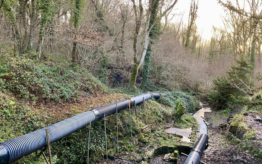
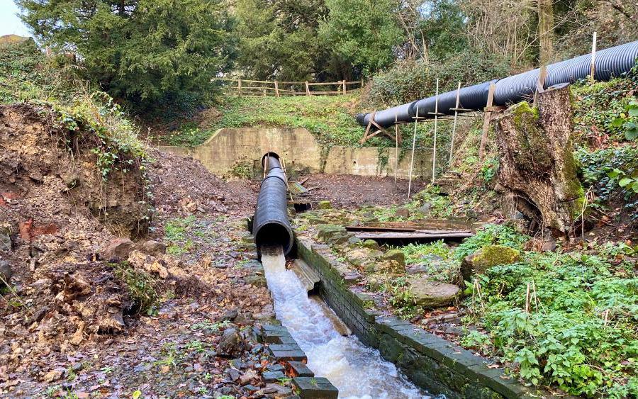
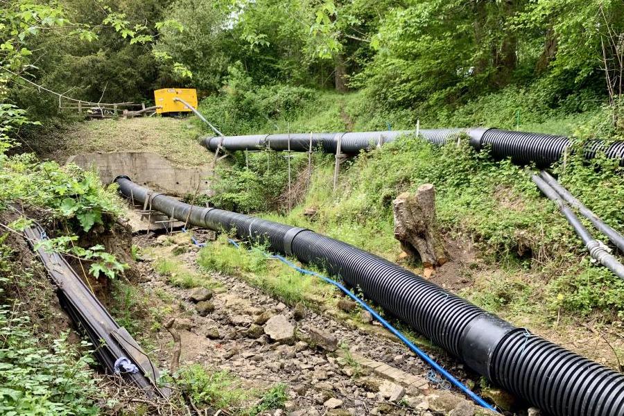
In 2016 temporary drainage pipes were introduced which carried flood water from the furnace pond, by-passing the archaeology and reducing the opportiunity further damage. These were funded by the preservation group through donations.
With high-hopes and renewed enthusiasm from volunteers, new plans were formed for a once-in-a-generation preservation project, using grant funding across multiple stages.
In 2017 and 2018 site surveys were conducted along with desktop planning and grant applications. In May 2021, significant earthworks begun to excavate the southern spillway and barrel arch.
Outreach and Education
The preservation group continue to tell the story about the operation of the furnace in Fernhurst, and about the once industrial nature of the Weald.
Each year we take an information stand to local village events, and we attend local groups to give talks.
On an annual basis, we hold an Open Weekend event in the fields around the furnace.
Conservation
The furnace site and the surrounding woodland provide important habitat for a range of flora and fauna. We’re particularly conscious to ensure our work preserving the furnace doesn’t disturb protected species.
Visitors along the footpath and bridleway can enjoy seeing an array of wildlife, with nesting grey wagtails, breeding mandarin ducks and a plethora of native mammals.
Documents
Newsletters
- Newsletter 2022 07
- Newsletter 2022 01
- Newsletter 2021 08
- Newsletter 2021 03
- Newsletter 2019 10
- Newsletter 2018 08
- Newsletter 2017 07
- Newsletter 2016 07
- Newsletter 2016 05
- Newsletter 2015 07
- Newsletter 2014 10
- Newsletter 2013 07
- Newsletter 2012 07
- Newsletter 2012 07
- Newsletter 2011 06
- Newsletter 2010 08
- Newsletter 2009 07
- Newsletter 2009 04
- Newsletter 2008 08
- Newsletter 2008 01
- Newsletter 2007 08
- Newsletter 2007 03